
| Jatbula Trail |

About |
 |
The Jatbula Trail claims to be Australia's premier dry tropic walking track. It is, in fact, an ancient songline of the Jawoyn people, traditional owners of this country. It follows a pathway from Nitmiluk Gorge to Leliyn (Edith Falls), 5-6 days walking and 62 km to the north. Much of the walk is spent wandering the edge of the Arnhem Land Escarpment, which overlooks the valleys and flatlands to the west. Here, water that has percolated into the porous rock of the escarpment plateau seeps out to create a series of waterfalls, cascades, waterholes and creeks along its edge. This creates a varied landscape of monsoon forest, dry savannah woodland, sandstone outcrop, grasslands, ancient rock art sites and magnificent natural water features. Certainly a track for the bucket list, and one that we finally get to tick off. |
Being in the tropics, the Jatbula can only be walked in the cooler Dry Season and, even then, temperatures over 30°C are common. When I first thought about walking Jatbula some years back, it wasn't yet a victim of its own fame - you could just roll up, sign in and walk. Now, however, it is usually booked out 12 months ahead for independent walkers and is a tightly regulated one-way walk with 15 walkers allowed per day over 5-6 days with no double-staging or dilly-dallying. This makes it more difficult to do, but more enjoyable once you can do it. |
|
 |
 |
The fair Nello and I had escaped (NB legally) from the covid restrictions of the south before border closures prevented this to head north. When I tried to book an independent trip on the Jatbula before leaving, I discovered the "fully booked until 2022" story. Not to be deterred, I found a local trekking company that had two spots left on its guided trip. We snaffled them up, not wanting to miss out. Fast forward a month and we are free in Katherine but the big cities of the south are in full covid-lockdown. All the others on the guided trip were locked down in the south, unable to get here for the walk, and it looked like being cancelled. Thinking that most independent walkers would also be unable to make it here, I retried to book that option. However, no-one had bothered to cancel (as it transpired only 2 of 15 independent walkers ended up on the track - the moral is, if you can't do a walk, Cancel!!!). After a 5000 km roadtrip to get here, things were looking a bit grim. As we we were about to wallow in self-pity, a guide from the trekking company knocked on our cabin door - they had managed to get another 4 people at short notice from Darwin (not in lock-down). Hallelujah, the trek would go ahead .... and that is how we got to walk the Jatbula Trail and how the fair Nello did her last multi-day pack hike before having a bilateral knee replacement. They breed them tough in her family. |
|


Day 1 - Nitmiluk Gorge to Biddlecombe Cascades (8.5 km - 150m ascent - 40m descent) |
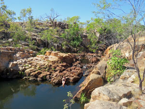
We arrived at the Gecko Base near Nitmiluk Gorge at 7am to meet our guide, Travis, and our fellow walkers, Marty, Vita, Skye and Lulu, before proceeding to assemble our food for the next 5 days. Once we were all ready, we were driven the 3km to Nitmiluk Visitor Centre for the obligatory safety briefing by one of the national park rangers, before finally heading down to the boat ramp on the Katherine River. Farewelled by Nitmiluk's notorious colony of fruitbats, a short ferry ride brought us to the northern bank of the river, in front of Nitmiluk Gorge entry, and the start of the Jatbula Trail. We disembarked at 9.15am and it was already feeling quite warm. |
||
 Katherine River ferry |
 |
 Looking into Nitmiluk Gorge as we cross the river |
 Start of the Jatbula Trail |
The first part of the track wound its way northwards up the valley of 17 Mile Creek, through the long dry grass that typified this savannah woodland late in the dry season. Passing an impressive pair of black basalt buttes to the west, we crossed a low ridge and soon found ourselves looking at the dark shaded wall of the escarpment. |
 Heading off into the dry savannah lands of 17 Mile Valley |
 A pair of basalt buttes |
 Heading towards the escarpment wall |
|
The vegetation became lusher and, after a short stony section, we arrived at North Rockhole, where, in the wet season, a waterfall tumbles down the escarpment into a dark-green plunge pool. At this time of year the waterfall had dried up, but the pool was full and a pleasant place for a snack break. |
|
 Northern Rockhole |
 Climbing a stony burnt slope away from the rockhole |
|
 Loooking up to the dry waterfall
From North Rockhole, we passed through a recently burnt patch of woodland to pick up a gravel service road. This led us on a steady climb up onto the escarpment. Though not hard, it was hot and the occasional puff of cooling breeze was welcome. |
||
 A change in landscape on the higher slope |
 |
 Road to the top of the escarpment |
 Pink-barked gum |
|
 Track through the denser escarpment vegetation |
On reaching the top, the service road flattened out, sometimes stony, sometimes deep and sandy. Not long after, we left the service road to quickly arrive at Biddlecombe Cascades campsite, set in a shady spot where lorikeets and honeyeaters feasted noisily on the orange brush flowers of tree grevilleas - a very pleasant place. |
||
 |
 Campsite at Biddlecombe Cascades |
 |

The name Biddlecombe Cascades suggested water nearby, so we hurried down to check it out before lunch. What a magnificent surprise it was - a series of sparkling cascades tumbling down through several tiers of rock pools and dropping further through the gap below us. The fair Nello and I headed to the upper pools - smaller, but soaking with the force of the falls, a veritable spa/aqua massage - and a great way to cool off after a hot walk. |
|
|
 Upper pool at Biddlecombe |
 A soak in the Upper Cascades |
|

That afternoon, we would check out the lower plunge pool - more the swimming hole of Biddlecombe - at the bottom of the wide silvery veil of the main cascades. This rock pool quickly became the focus of the afternoon - the perfect way to escape the 35°C heat.
|
 Looking into the lower pool at Biddlecombe |

Thus, the pattern of Jatbula was established - hard walking in the morning before the heat of the day set in and enjoying the natural water features of the region during the hot afternoons. I think that I can handle that. The only annoying feature was the occasional passage of a low flying helicopter. Tourists from Nitmiluk like to view the water features of the escarpment from the air - nice for them, but not for the tranquility of these beautiful sites. As night fell, we enjoyed a great meal cooked up by our guide, Travis, before adjourning to a nearby rocky ridge to enjoy the clarity of the night sky - a brilliant display of stars and the milky way. Then it was off to bed to continue star-gazing through the mesh of our tent (no fly needed in this climate) as the nectar feeding birds were replaced by fruitbats, crash-landing in the trees to have their turn feasting on grevillea blossoms. It was a great start to the walk. |
|


Day 2 - Biddlecombe Cascade to Crystal Falls (11.5 km - 150m ascent - 140m descent) |
We heard Travis call out good morning - it was 6am and still dark, but in this country you need to be on the track early to avoid the heat of the day. So, soon after 7am, we were packed, breakfasted and off, following the Jatbula Trail through the marshy swampland behind Biddlecombe Cascades. Then, it was a quick removal of boots to cross the creek, a reboot and onwards. |
||
 Traversing the wetlands above the cascades |
 Shoes off to cross Biddlecombe Creek |
 Back into the open spinifex woodland |
We soon found ourselves heading across flat savannah woodlands, carpeted with the pale green tussocks of spinifex. Travis seemed to be setting a slightly quicker pace today - perhaps because of the cooler early morning start, perhaps his pack was lighter after preparing last night's dinner or perhaps he had been assessing us on the first day and approved of our abilities. I prefer to think it was the latter. The early morning sun cast long shadows across the landscape, not only of trees, but of the needle-shaped termite mounds that dotted the grasslands. |
||
 Following a rocky creekbed in the stone country |
 |
 Sandstone outcrop and rock art site |
Gradually, we noticed the low rock ridges on either side were narrowing and funnelling us up a small valley that parallelled the escarpment. We were entering Stone Country and the valley narrowed to a rocky creek bed. We climbed steadily upwards past small rockpools to reach a point dominated by a large sandstone outcrop. |
|
|
 A large spiritual being |


It was a shady spot and Travis called a halt, not just to munch on some scroggin but to show us some Jawoyn rock art - some of the ochre paintings were perhaps 4,000 years old, while another dated at 8-13,000 years old. It was incredible to contemplate how long feet have been walking the path we now trod. |
||
 Lusher creekbed vegetation |
 Open woodland on the escarpment plateau |
 Termite mounds amongst the spinifex |
Heading off again, we climbed a dry woodland hill before dropping back down into the next creek system - a thin line of lush greener vegetation marked the course of the boggy creekbed. We crossed to begin a series of traverses, in and out of shallow valleys, before stopping for a rest at a point where we could make a short detour to the edge of the escarpment and look down its length and out over the arid flats of 17 Mile Valley. |
 A curiously deformed tree |
 View over the plains from the escarpment edge |
 Escarpment vegetation |
Pushing on, we passed through a recently burnt area (control burn)- it was more exposed here, the sun was beating down and sweat began to trickle down my face. Now I knew why we had left so early. |
||
Dropping down to meander through a dry rocky creek system, Travis stopped beneath a small rockface to show us a second Jawoyn site with slightly different rock art. |
||
 Rock art site in a dry creek system |
 |
 |
With the temperature already into the 30s, our thoughts were turning towards the pools of Crystal Falls. One last climb out of the rocky creek bed, a walk along a hot dry ridge and the deep creek valley lay below us, heading towards a gap in the escarpment. |
||
 Kapok tree on the edge of the escarpment |
|
 At last the pools of Crystal Falls |

It isn't often that the sight of a long-drop toilet brings happiness, but this one announced our arrival at Crystal Falls camp, set beneath shady trees right next to the water. The creek here comprised a wide section of rapids and fast-flowing rocky channels, but behind that was a lovely clear cool waterhole, perhaps 100m long, fringed with blue and white water-lilies. |
|
 Part of the clear swimming hole next to our campsite |
 View down the rapids at Crystal Falls |
We pitched our tent quickly and jumped in to soak off the sweat of the walk, before a leisurely lunch. As before, the afternoon was free to read, write notes, swim, explore or relax in the shade. |
||
|
 Shadt campsite at Crystal Falls |
 |

Crystal Falls is a lovely spot - calmer than the tumbling waters of Biddlecombe, but, with the chance to have long leisurely swims beside the lily-pads and spot the odd turtle or water monitor, it was the perfect complement to it. There is an old saying that "it is about the journey, not the destination". With the promise of more days like this, we were starting to think that Jatbula is about the destination, not the journey. |
|


Day 3 - Crystal Falls to 17 Mile Falls (10.5 km - 120m ascent - 100m descent) |
Another hot day - another early morning wake-up to start our walk in the cool of the day. This time we packed everything up, but left our boots off. The first part of today's walk was a barefoor wade/rock-hop to cross the wide stony section of Crystal Falls Creek. |
As I put my boots on on the other side, I found myself wondering why this flattish section of water with a few rapids and cascades was called Crystal Falls. Around the corner and up on top of the stony gorge wall, the question was answered. |
|
|
 Wading the rapids at Crystal Falls |
 Looking down on the actual Crystal Falls - impressive! |
|

Below us, Crystal Falls plunged in three mighty leaps into the shadows of a chasm - it well lived up to its name. The climb out of the rocky gorge system continued steadily across a stony side creek and pushed on upwards. I had the feeling that the escarpment itself was graduallly getting higher, as the climb comtinued steadily into a landscape of scattered small eucalypts and pale green spinifex. It was only a bit after 8am and already drops of sweat began to trickle down my back. Thankfully, by the time we reached the tops, a cooling breeze had sprung up. |
||
 Now that's a big termit mound |
 Wetland flats .... |
 .... and termite mounded grasslands |
Continuing on through this open spinifex woodland, we set a steady rhythm - somewhat meditational with the steady crunch of boots on the gravelly track surface. This was the land of termites, needle-like towers and cathedral like domes in orange or grey carton. |
 The lush tree-filled hollow of The Amphitheatre |
The flat walking continued, crossing a sedgy dry swamp, with the odd scattered buffalo pat, to reach The Amphitheatre. Here a large rock-walled cirque intrudes into the escarpment, to create a special microclimate filled with taller trees and lush vegetation. It is a sacred place for the Jawoyn people and the orange-walled cliffs house some of their rock art. |
 Descending into The Amphitheatre |
|
It is permitted to visit these, so we dropped our packs and followed Travis down a short steep track into the cool shade of The Amphitheatre to view the galleries with pictograms of animals, humans and spiritual beings. |
||
 |
 |
 |
|

Climbing back up, we slung our packs back on and walked the final few kilometres into the campsite. Part of this followed a National Parks service road, which made for a steady trudge, the rest was on a footpad through drier more open vegetation. Eventually we reached the edge of the escarpment and could look out to the west down the length of the 17 Mile Creek valley. The more spectacular view, however, lay to the north, where 17 Mile Falls plunged 50m down through a deep gap in the escarpment wall and into a dark green plunge pool. |
|
|
 View down the 17 Mile Creek Valley |
 Termites on a burnt landscape |
|

Our campsite for the night lay a little upstream from the falls and we quickly descended to it. Not quite as shady as previous campsites, it made up for it with its sandy floor and the fact that it was adjacent to a long and deep waterhole - ideal yet again for a refreshing swim before lunch. |
||
|
|
|


The afternoon was free for more swimming and exploration of the upper reaches of this low-walled gorge system, where water tumbled down narrow gaps through a series of smaller pools separated by water-polished orange and black boulders. It was once again a very special setting to pass the afternoon, as the mercury rose to 35°C. |
|


Day 4 - 17 Mile Falls to Sandy Camp (18 km - 80m ascent - 120m descent) |
It was a 5.30am wake-up today. The next campsite was 18 km away and Travis wanted to get us there by lunchtime. As we left camp, the sun burst suddenly above the big waterhole that we had called home for the night - a fitting farewell. We back-tracked a little to cross the creek downstream, clambering over the rocks just above two small waterholes and the waterfall itself. These upper reaches of 17 Mile Creek form a long series of waterholes of different sizes and surrounds - a stunning landscape. |
||
 Morning sun breaching the horizon at 17 Mile camp |
 Rockholes above 17 Mile Falls |
 Open spinifex near the escarpment edge |
We climbed up and out of this rocky cleft in the escarpment to re-enter more open woodland country and undulate our way past several shallow creek valleys. The track then headed west for several kilometres across a flat eucalypt dominated grassland. With the morning coolness lingering, a sameness of landscape settling in, the sweet call of a butcherbird permeating the trees and a rhythmic crunch of boot on gravel, it was easy to enter the zen zone of walking and let the mind wander free. |
||
 Rock ribs cutting into the landscape |
 Crossing the big flat |
 Open woodland on the way to Edith River |
The flatness did not last forever, though, as we meandered our way across a couple of creek systems and over a low saddle. We had now turned north to enter the catchment of the Edith River and its broad, shallow valley. The change in landscape was quickly evident - lusher, greener vegetation, taller eucalypts and the appearance of pandani. It was a much shadier place to walk and, with temperatures again on the rise, we were grateful. |
||
 Pandani appearing in the Edith Catchment |
 Lusher vegetation of the Edith Valley |
 First glimpse of the Edith River |
A low rock ridge on our left guided us towards the river. On reaching it, the track again turned west to follow its shaded corridor - mainly in the trees, but with occasional glimpses of the Edith River itself. On reaching a point where the rocky rib crossed the river via a set of flat, water-polished slabs, we switched to the northern bank for a break beneath a shady tree. |
||
 |
 Edith River Crossing |
|
Continuing on this side, we climbed up into a ruggedly rock outcrop - hot work with the pale pinkish slabs reflecting the heat. It was worth it, though, as the track led to Channels Waterhole, where the Edith River has carved a mini-gorge through a wide band of rock - very impressive. A large tree-trunk wedged in the rocks high above the water-level gave a hint of the force of wet season floods. |
||
 Heading back into stone country |
 Channels Waterhole ... |
 ... and its mini-gorge |
From the rocks, we headed back across more open country before once again entering the densely vegetated river corridor. One more crossing of the Edith, on a short log embedded in a boggy section of creek, brought us back to its left bank again. |
||
 |
 A lush water-lily pond on the Edith River |
 |
From here, it was a final meander along the sandy river corridor to emerge at Sandy Camp and its waterhole. What a sight it was, after 18 km - the river cascading over the red rocks into a long tree-fringed waterhole. |
|
 Sandy Camp Waterhole |
 Evening reflections at Sandy Camp |
 The waterhole at the edge of Sandy Camp |
 |
 Whiling away the afternoon |
We crossed to reach the delightful sandy and shady campsite on its northern shore, pitched camp and jumped in. Parts of the bank were also fringed with with fern-like aquatic weeds that swayed gently in the current. Swimming here was like drifting through a low aquatic forest. The wildlife highlight here (beating the sight of a long-nosed turtle feeding on the waterweed) was that of a small python devouring a lizard - life in the outback goes on. |
||
 Time for a late lunch at the waterhole |
 Far end of Sandy Camp waterhole |
 The Socrates wrap (a fine dessert created by Marty) |
The dinner that night was a jovial affair, made complete by Marty's creation of the "Socrates Wrap" for dessert, combining all sorts of sweet substance from the larder, along with a dash of philosophy. It is interesting how the group dynamic evolves on a walk - the first two days being friendly, but a little reserved, while by day 3 the camaraderie of the track had fully kicked in. |
|
Day 5 - Sandy Camp to Leliyn (15.5 km - 40m ascent - 000m descent) |
The last day of our Jatbula hike dawned and, as before, we were already up, packed and heading off. There are few things more constant than the dry season weather in Northern Australia, so a clear blue sky with expected temperature of 34°C was no surprise. Leaving the pleasant setting of Sandy Camp, we briefly followed the densely vegetated bank of the Edith River along a deep sand track before heading slighty more inland into more open woodland country, though never too far from the river. The pace seemed to have picked up a bit - perhaps a bit of last day energy, or was it the promise of a buffalo burger at the Edith Falls Trailhead? |
||
 |
 Early morning stillness at Sandy Camp |
 |
Speaking of which, this country is home to feral buffalos, as attested by the dried pats that we regularly passed on this moister landscape. None were to be seen, however. The main wildlife on this section were the garrulous lorikeets, squawking away as they feasted on the blossoms of grevillea and eucalypt trees. |
||
 Heading back into the flat lands |
 Passage through the long grass |
 A tranquil pool on the Edith River |
The day was warming up and, while an easterly breeze kept us cool in the open woodland, we soon started dripping perspiration in the closed riverside forest. For much of this section, we meandered through tall dry grass at a steady pace, which was shattered by a bout of leaping - one upwards and two backwards - an encounter with a snake on the track will do that. The large black snake slithered of into the long grass - that put a renewed sparkle into our steps. The track now crossed a small side-creek and we were soon wending our way across some muddy swampland on a short section of boardwalk. Ahead we could see the opposite bank rising above the river - the landscape was starting to change again. |
||||
 |
 |
 The Edith River wending through the rock ribs |
 |
 |
On reaching the river, we faced its rocky bed and low rock walls on either side, before turning to follow the broken rock slabs westward to reach Sweetwater Pool - a couple of small waterholes separated by short cascades, the last of which poured into the large dark pool of Sweetwater. It was our last chance for a swim on the Jatbula and we quickly swapped sweaty walking gear for bathers to luxuriate in its refreshingly cool water - the coolest of all the waterholes on the trail. |
|
 The magnificent setting of Sweetwater Pool |
 Time for a dip in its crystal clear water (photo: Skye) |
Sadly, we could not stay here and, after our cool down, were back on the track for the final 4 km push to Leliyn (Edith Falls). Sidling our way around Sweetwater, we crossed sections of jagged rock ribs and flat scrubby stunted trees to reach Long Pool, the last of the waterholes on our adventure. Quite a few people were enjoying the pool - we had reached the edge of civilisation and many day-trippers walk in from Edith Falls to swim in these upper pools. |
||
|
|
|


We continued on to do one last climb on a rocky path over the rounded hill to the north of the Edith Falls Gorge that marked the edge of the escarpment. Just over the top, we reached the sign marking the formal end of the Jatbula Trail - it was time for the traditional end-of-walk group photo. |
|
 Successful completion of Jatbula - August 2021 |
 |
All that was left now was a 630m long downhill stroll to reach the car-park and officially end our adventure - time for high fives all around and a stop at the cafe for our buffalo and/or barramundi burgers and chocolate milkshakes (the best rehydration drink, I am told) - delicious. Thanks Travis, for being an excellent guide and cook, thanks to Skye, Lulu, Marty and Vita for your pleasant company, and thanks to Hayley and Chris?, our friendly independent walkers, whose path we frequently crossed. Good camaraderie on the track makes for an enjoyable experience, and the our Jatbula Trail adventure was really enjoyable. |
||

|
