Thus, I followed the development of the trail with interest and, when the I heard that it was to be opened in late October, decided to "preview" it, but from a walker's perspective. The first task was to reassemble the downloadable gpx file of the track from the website so I could use it on my mapping software and GPS - it had curiously been cut up into almost 100 segments of varying length from a few metres to several kilometres, some of which were reversed, and also lacked elevation data. I like to walk with a GPS and needed a usable file. For those who might find it useful, I offer a link to this cleaned-up, elevation enhanced, GPX file of the trail, as the original one seems to have vanished from the rapidly evolving trail website (though it should be used to complement a paper map not replace it).
The description and photos on these pages therefore include a number of "variants" to the official track, these being primarily to include summits and ridges that might provide panoramic views, to avoid walking beside busy roads as much as possible and to short-cut those long sections that seemed to have no other purpose than to get cyclists comfortably from A to B. Variants themselves are not a bad thing - all great trails have them - and hopefully the ones suggested here will improve the experience of the trail for walkers. In so doing, the trail is reduced to a bit over 130 km - a bit less walking for a bit more reward. Files of the trail, as walked here, can be downloaded from links on the next two pages.
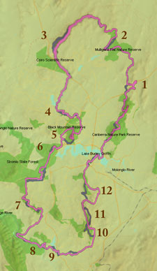
The trail itself is a circuit, but can be broken down into several sections with different start and end points. The official website for the trail lists seven sections, most around 20 km long, but with one longer and one shorter day and provides maps of these in PDF format (as does the Canwalk site). However, these do not always coincide with public transport and not everyone will have a car or be able to set-up a car-shuffle if they do. A secondary objective of my walk was to see whether and how the track could be walked using Canberra's buses - after all, walking the urban fringe gives one the benefits of urban infrastructure - in particular, public transport and good coffee shops.
So read on, fellow walkers, and see what Australia's latest long distance track has to offer. If you want to go straight to the trail description and photos and not worry about map and bus details click here.