Cuvier Valley - Mt Olympus
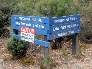
Day 1 – Narcissus Hut to Lake Petrarch (10km - 410m ascent – 290m descent)

I am sitting here on the white sand beach at the southern end of Lake Petrarch, backed by gnarled eucalypts and stately pencil pines, looking across the sun-silvered waters at the dark line of peaks on its far shore. It is warm in a sunlight filtered by high cloud and I am feeling really clean for the first time in several days after a dip in its shallow tea-coloured water. This is a very different landscape to the ragged edges and stark walls of the Duane Range only a few kilometres away, and a place of absolute serenity.

To get here we left Narcissus Hut at 10am – a late start, but one determined by the arrival of our extra food supplies on the Lake St Clair ferry following completion of the Du Cane Circuit. It had been pleasant having a “lazy” morning in the sun at Narcissus after four days of hard walking, but eventually it was time to head on and continue our exploration of this world heritage region under the guidance of Rupert, with his 50 years of experience walking in this wilderness.


The beach near our campsite at Lake Petrarch


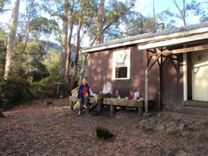
Marg and Alan enjoy breakfast at Narcissus Hut

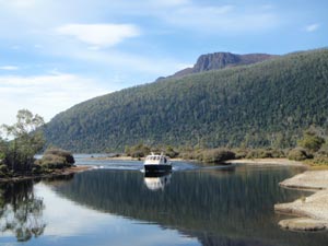
The food supplies arrive by boat

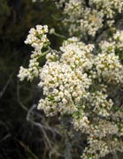
Boardwalk across the swamp near Narcissus
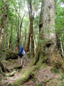
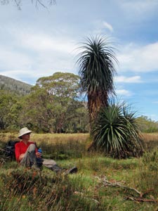
The track led us quickly westwards away from the hut, across the board-walked swampy areas and grassy flats. My pack certainly pushed down harder on my legs, a combination of extra food and more tired muscles. Soon though we were back in the tall mixed beech forest, with the birds singing in the tree tops above us (even they couldn’t believe we’d had five consecutive days of perfect weather).


Once more into the forest


Frenchman's Cap - over 30km away to the south

However, by the time we reached the junction in the track, we were back in the damp green silence of old myrtle beech forest. One route led back to Cynthia By on the last section of the Overland Track as it followed the shore of Lake St Clair. We took the other, passing the sign warning that it was no longer maintained, and soon found ourselves climbing through the mossy mounds, gnarly roots, fallen trunks and massive trees that constitute old growth forest.


Passing a forest giant


Brown gums and pandani

The forest is not just myrtle beech, but smaller trees such as the fragrant sassafras and leatherwood, festooned in white blossom, and the towering swamp gums, reaching up 40m high above the canopy from massive butts.


On Byron Gap

Beech forest is a sublime place, but is also very humid and I was feeling damp and sticky as our climb progressed - steep pitch followed by gradual traverse, the up and down of creek crossing, detours around fallen trunks and then repeated all over. Eventually the myrtle beech forest was replaced by more open and scrubby eucalyptus, as we reached the point we were aiming for, Byron Gap, at the northern end of Mt Olympus. It was a good spot for lunch.

From here we quickly descended the southern side of the gap through stands of brown gum to rustle past the dry-leafed trunks of pandani and down in to the tea-tree scrub where the track turned spongily boggy. This brought us out into the Cuvier Valley and, across the grasslands and reedbeds, we could see the broad waters of Lake Petrarch - a thin strip of white sand glistening at its far end.

We skirted the eastern flank of the lake, where the unmaintained track disappearing in parts into thickets of tea-tree regrowth, head-high but sweetly aromatic. After a bit of scrub-bashing, we rediscovered the track, and a very muddy one at that. As Alan and I found out later when removing our boots at camp, it was also a place where leeches lurked.


Mike takes a break

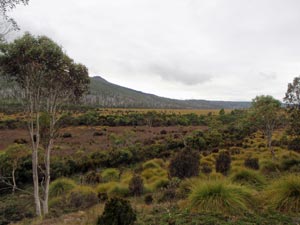
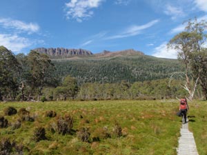
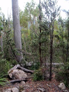
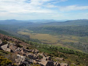
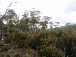
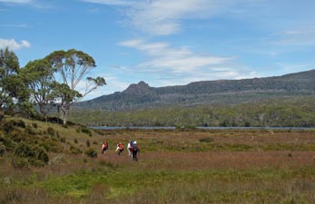
Heading south down the Cuvier Valley

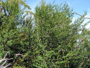
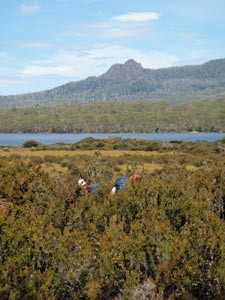
In the tea-tree scrub near Lake Petrarch

On reaching the southern end of the lake, we cut down to the shoreline and found a flat and mossy camp site, sheltered by pencil pines just a few metres from the white sandy beach. It was only 3.30pm and we had the rest of the day to enjoy this superb setting.


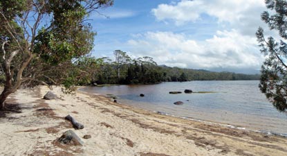
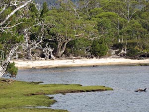
The shore of Lake Petrarch

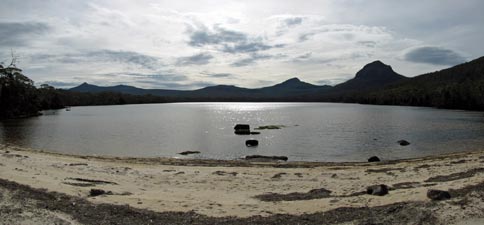
Tranquil moment at Lake Petrarch

It almost felt sacrilegious to walk along the beach - there was no sign of a previous human footprint, just the tracks of the local fauna - wallaby, quoll, goanna, wading birds and others. The lake was shallow, but that took the chill off the water and we could have a refreshing soak as the high cloud drifted over and the filtered sunlight sparkled on its silvery surface. This isolated beach in the middle of the Tasmanian wilderness was the perfect spot to sit, let the mind wander off into a zen-like trance and absorb the tranquility of our surrounds.


Day 2 – Climbing Mt Olympus (8.5 km - 580m ascent – 580m descent)

The wind began to pick up about 2am, gusting through the pencil pines above our camp site. Morning dawned grey with the odd spit of rain, but the cloud was high and the temperature warm.

Alan and I had decided to join Rupert on a climb of Mt Olympus, which towered over our tents to the east. Five times in the past he had planned to climb it, but for one reason or another could not do so – today was to be his day. Although the climb was only 580m, that was either thick steep scrub or boulder scree – not a trivial exercise. Marg and Mike opted to stay at base camp and enjoy our 5-star campsite on the shore of Lake Petrarch.

With our pack weights greatly reduced for the day, we skipped out of camp only to be immediately showered on. However, it proved to be the last shower of the day and the sky was starting to clear from the north-west. We followed the yellow ribbons that marked the Cuvier Valley Track southward for about a kilometre through thick tea-tree scrub and across boggy water-filled flats.


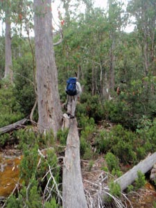
The easy way up in the scrub - on a fallen trunk

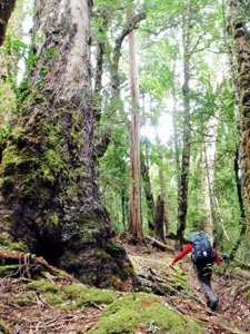
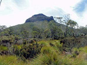
Lower slopes of Olympus

The sun was out by the time we reached a spot with an opening in the scrub towards the western flank of Olympus. Rupert took a bearing and we headed off-piste, soon finding ourselves bush-bashing our way through thick stands of tea-tree to reach the start of the climb. The slope was not much better – low scrubby bushes between tall eucalypts and a tangle of fallen trunks and branches. However, Rupert introduced us to the bushman’s highway, walking directly up the trunks of some of the fallen trees to gain precious elevation free of scrubby entanglement.


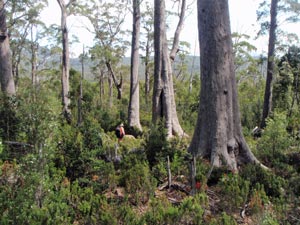
A dense thicket of deciduous beech (aka tanglefoot)


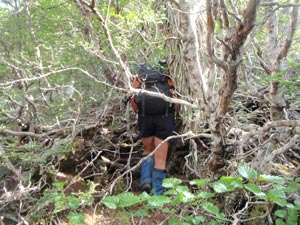
Rupert finding a path through the tanglefoot

Thus it went for the next hour and a half, as we pushed, pulled and barged our way through scrub of varying thickness and increasing steepness, until we finally crashed our way through a band of deciduous beech (known to the locals as tanglefoot). This brought us out into the open and the start of the scree – big blocks of orange dolerite, patterned black, grey and white with lichens. Below us, we could finally see Lake Petrarch and the white sand beach near our campsite. Soaked in perspiration, I could imagine Mike and Marg lazing on the sand and wondered whether it might not be too late to join them.


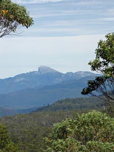
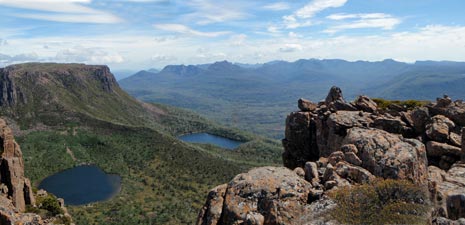
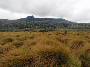
View from Olympus over the Cuvier Valley

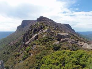
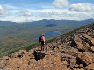
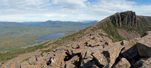
Rock scree on the spine of Mt Olympus - Lake Petrarch in the background


The route up to the summit of Olympus

We were at the base of a long tongue of scree that led up to the razorback ridge joining the two plateaus of Olympus. Without heavy packs, and consequently a restored centre of balance, we rock-hopped, hand-hauled and otherwise climbed our way transversely to the ridgeline. At the crest wonderful views opened up over Lake Oenone tucked into its hollow cirque beneath the plateaus of Olympus. It also opened up blasts of a strong north-easterly wind, from which we had been sheltered during the climb.

From here we could see the high point of the mountain on the eastern side of the southern plateau. We continued clambering over the jumble of massive dolerite blocks, keeping beneath the ridgeline in the lee of the wind, to finally emerge on the plateau – a rough-surfaced dry and windswept landscape of shin high scrub. Hanging on to our hats, we crossed the plateau and reached the stone cairn that marked the summit of the ”home of the Gods” (at least their southern hemisphere address). The climb had taken 4.5 hours and Rupert had finally reached the top of Olympus. Alan and I were glad to be part of that achievement.


Cairn marking the summit of Mt Olympus


Peering down from Olympus to Lake St Clair


The northern end of Mt Olympus above Lake Oenone and Lake Helen


View between the plateaus of Olympus towards the Narcissus end of Lake St Clair

From the plateau rim, there were tremendous views in every direction – to the east, directly down onto the wind-waved waters of Lake St Clair, to the north we could see the route of our recent circuit of the Du Cane Range, southward lay mountain ranges some 100km distant, while to the west the tops of the closer ranges were covered in cloud. Now that wasn’t in the script! Thick cloud was definitely moving in and we didn’t want to be up here in a white out.


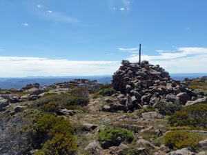
Rupert surveys the descent route

Pine and scrub on the higher slopes

Tall eucalypts on the lower slopes

It was time to descend, reversing our track – clambering down the boulder scree, carefully avoiding the tanglefoot beech barrier, but still having to crash our way through head-high tea-tree thickets and lower scrub, hop down steep slopes of sandstone boulders, beautifully patterned in cream, grey and pale pink lichens, as well as strolling down the odd 40m fallen tree trunk to reach the Cuvier Valley Track 40m from where we had left it. From here it was just a quick walk back to camp, where Marg and Mike greeted us with a hot cuppa and Lake Petrarch greeted us with a deliciously cold dip.


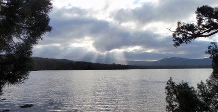
Sunrays at Lake Petrarch


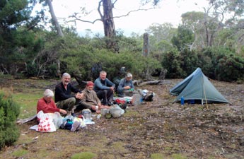
Dinner at Petrarch campsite

Looking up, the cloud had enveloped the tips of Olympus, hiding the upper parts of our route – once again the weather pattern had favoured us and we felt privileged. No matter what conditions were like tomorrow, for our trip it was “mission accomplished”.


Day 3 – Lake Petrarch to Cynthia Bay (12.5 km - 110m ascent – 210m descent)


We awoke on our last day to a perfectly still morning with high cloud covering the sky and lower cloud obscuring the summits of the mountains around Lake Petrarch. It was a good day to be heading back to civilisation, with lighter packs and even lighter spirits after another successful walk in this World Heritage area.

Leaving the serenity of Lake Petrarch behind, the reality of this landscape quickly set in as we crashed our way through the dense tea-tree scrub overgrowing the remnant Cuvier Valley track, and then side-skipped or squelched our way through the boggy flats, before finding a steady rhythm as the track entered an area of forest. A series of yellow ribbons and the occasional old tape marker on a rotting stick were our guides through on what is left of this track. Occasionally nothing was left as thick scrub or a fallen tree hid the route and we had to stop to scout out another marker. Fortunately, there always seemed to be one when you needed it.

The clearer parts of the track seemed to be a site of choice for Tasmania’s notorious jack-jumper ants to build their colonies – not a place to stop and wonder where next to go.  In Tasmania, more people die from the stings of these ants than from snakebite (primarily due to allergic reactions). The calm disposition of the whip snake that watched us pass by, compared to the hyperactivity of these ultra-aggressive ants made it clear to see why. As Alan would later find out, sit down to close to one of their nest and you risk getting stung on the backside.


White-lipped whip snake


On the edge of the plain


Button grass plains of the Cuvier Valley


Once through the forest, the route led us out across the button grass plains on a track that would be impossible to see from 5 metres away – a meandering narrow erosion gully of varying depths and varying bogginess mostly overgrown to the extent that you could not see where your foot would land. Such track is a potential leg-breaker and our progress slowed considerably as we picked our way across the yellowish-green sea of grass, stopping on a couple of flat rocks for a leech-free morning tea, before continuing across this strangely beautiful plain. Behind us, the foggy heights of Mt Olympus and the Seven Apostles began to recede into the distance.


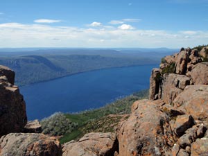
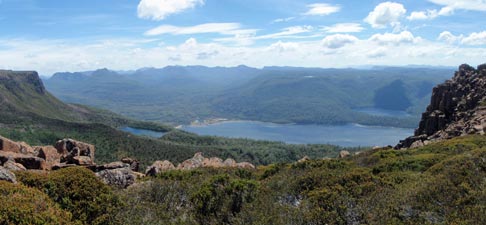
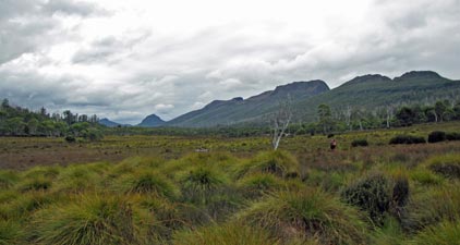
View back up the Cuvier Valley towards Mt Olympus and The Seven Apostles
(I'm not sure where the other five went)
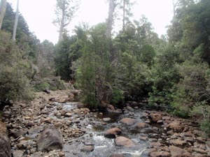
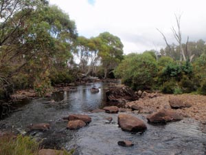
Eventually, tea-trees and other shrubs began to intrude into the button grass and the ferns and sedges became more common. The track disappeared totally, then reappeared clearer and firmer underfoot to bring us to the banks of the Cuvier River – a pleasant spot for lunch listening to the babbling of the water that had followed us down the river from Lake Petrarch.


Cuvier River


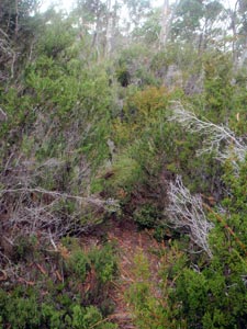
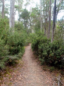
Back into the scrub one last time

The valley was now narrowing quickly and we found ourselves climbing slowly up the forested wall of a shallow gap, once again pushing our way through scratchy scrub (bottlebrush thickets this time). After a while, we climbed over a saddle to cut off a big bend in the river and descended through a sometimes tunnel of shrubbery – tea-tree, bottlebrush and hakea taking turns to try and impede our progress.  Then, all of a sudden, everything was clear – the track was wide and flat, and the well-behaved bushes kept their distance on each side. We had rejoined the well-managed Overland Track coming down from Narcissus Hut to Cynthia Bay – how easy it was to stroll along this bushwalker’s highway.


The not maintained track via Lake Petrarch


The beauty of lichen


Track junction - two ways to Narcissus (see photos on either side)

Crossing Watersmeet, where the Cuvier and  Hugel  Rivers join, we quickly covered the distance to Cynthia Bay Visitor’s Centre and the end of our walk, a bit under 6 hours since leaving Lake Petrarch. The difficulty of the access to this pristine lake should ensure it remains that for some time yet – a hard-earned gem in the wilderness.


The confluence of the Hugel and cuvier rivers


The well-maintained track via Echo Point


Official end-of-walk photo

The official end of walk photo showing the ravages of 7 days in the bush on erstwhile clean-cut and well-presented people was followed by a hot shower (thanks to Alan and Marg for giving us the key to the Cynthia Bay cabins shower block) and cold celebratory beer (except for poor Rupert who had to drive us to Hobart).

With the combined Du Cane Circuit, we had spent seven days walking through some of the most spectacular and rugged landscapes that I have visited. It was not a walk that I could have organised on my own and a big thank you is due to Rupert, who led us across the difficult and often trackless terrain to show us “his Tasmania” – which he clearly loves and loves to share his broad knowledge about. Thanks also to my other companions de route, Alan, Marg and Mike – together we had a very pleasant time and were able to laugh off the aches and pains of long days beneath heavy backpacks at those wonderful campsites deep in the Tasmanian wilderness.