| Blue Waterholes |
About |
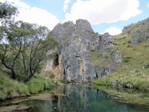
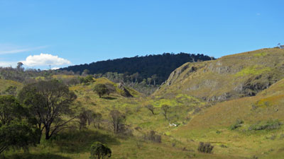
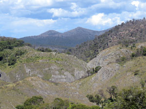
The northern end of Kosciuszko National Park is very different from its more frequented southern regions. Here the landscape comprises woodland hill-tops and broad, undulating grassy plains. An abundance of limestone has resulted in karst landforms, with narrow gorges, cave systems, vanishing creeks and spring-fed waterholes. The best way to see all of this is by spending a few days at Blue Waterholes, with its serene campground. Moreover, there are a couple of great shorter walks in the area with multiple stream crossings, gorges and caves to explore - a great place for younger children to enjoy the high country. |
||
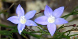
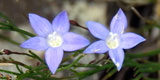
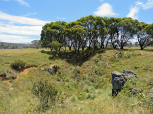
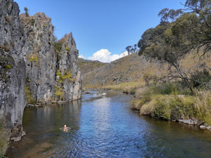
 The Blue Waterhole |
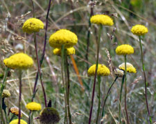
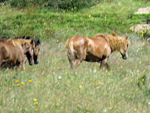
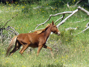
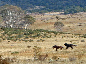 Brumbies on the Cooleman Plain |
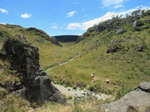
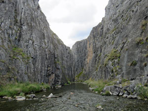 Gorge in the Karst landscape |
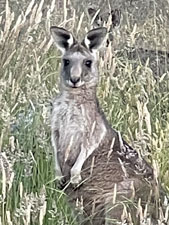
This was the plan for my daughter, three grand-children and myself during the January school holidays. We chose the dates well, as down in Canberra the temperature was set for the mid-30s, while here in the high country, the days were a much more pleasant high-20s. Thus, I loaded my small tent and gear into their off-road camper-trailer and away we went. Sadly, the fair Nello did not come, as she is suffering from a pinched nerve in her lower back and, for the moment, walking is a far from pleasurable experience. Crossing the low range between Adaminaby and Kiandra, we were shocked to see how badly the fires of 12 months ago had impacted the region - the forest was carbonised ... skeletal trunks and very little recovery. It will be decades before these woodlands are back to normal in this cold high country. Fortunately, much of the northern park was spared and we soon were driving up the gravel Long Plain Road, skirting snow-gum woodland and open grassland. A mob of brumbies grazing in the distance attracted the attention of my horse-loving grand-daughters. The descendants of escaped horses, brumbies are a divisive animal - iconic beast of the high country to some, destructive feral animal to others. A discussion about them can quickly raise high passions and turn to angry exchanges. Yes, a wild horse is a magnificent creature and my grand-daughters are horse-riders and passionate about horses, but they can see that the Kosciuszko National Park is no place for them. There are now 14,000 of them in the park and their hard hooves destroy stream edges, sphagnum bogs and the habitat of myriad native creatures and plants. I won't pursue this further. |
||
|
|
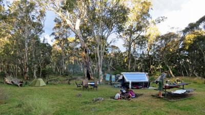
A little later, we turned off on to the Blue Waterholes Road and arrived at Cooleman Mountain campsite, our home for the next three nights. With school holidays and reduced numbers due to Covid, we hadn't been able to book a campsite at Blue Waterholes itself, but this was only a few kilometres further away and, with plenty of open space surrounded by some superb forest, it was ideal. |
|

|
|
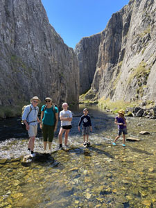 The Blue Waterholes walking team of 2021 |
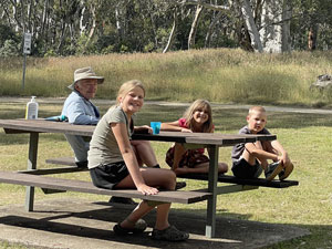
We set up camp, enjoyed a tasty meal that the fair Nello had provided and readied ourselves for two days of wonderful high country walking. |
||
|
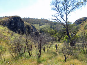
Clarke Gorge Walk (5 km -50m ascent - 50m descent) |


|
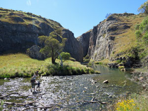
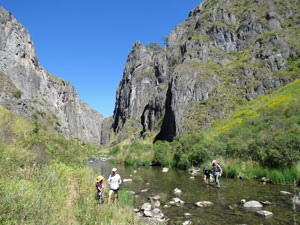
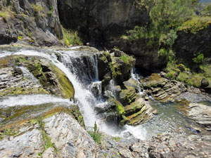
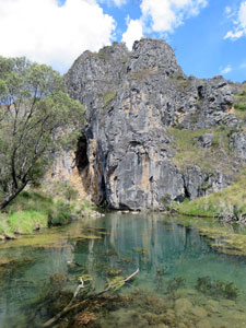
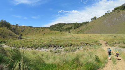
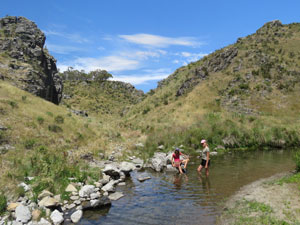
The morning of our first walk dawned near-perfectly, with clear blue skies and a pleasant temperature. It was only a short drive from Cooleman Mountain to Blue Waterholes past the old 19th century Coolamine Homestead, a reminder that this was once summer grazing country before becoming a National Park (note to self - we'll stop here and check it out tomorrow). Soon we were at the carpark, checking our gear and putting on our day-packs - the one critical item not to forget, neoprene waterboots. Blue Waterhole, itself, is spring-fed and the icy subterranean water flows out of the pool and down the stony bed of Cave Creek. This was our route through Clarke Gorge and, with eight crossings of cold creek waters ahead, purpose-designed footwear was a necessity, not a luxury. |
|
Leaving the carpark, we quickly descended the grassy slope, past several dead burnt bushes (the spotting in this area was as far as the big fires of January had come and, while areas of burnt trees could be seen on the plateau to the east, the gorge itself had been spared). We soon reached the first creek crossing, the water clear and cold with a bluish tinge from the dissolved limestone. We changed into our waterboots and set out - a line of stepping stones marked the crossing, but it is probably better to cross just upstream from these in the shin deep water, as the rocks can be very slippery and some are unstable. |
|||
 Heading down the grassy slope .... |
 .... to Cave Creek ...... |
 ... and the first water crossing |
|
 |
 |
We were now approaching the entry to Clarke Gorge and the water-crossings were becoming an adventure for the kids. |
 |
 |
|
|
|
||

|
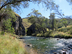
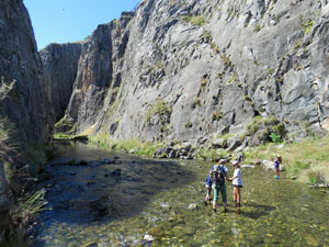
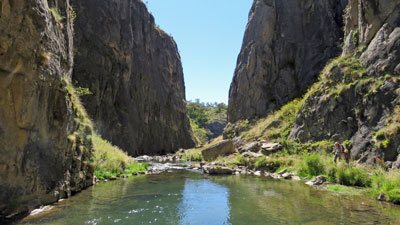
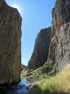
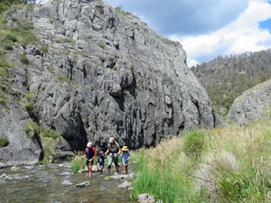
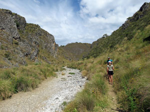
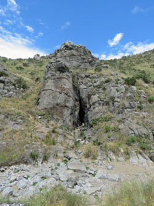
The narrow entry to the gorge lay just ahead, inviting us in and, after a third creek-crossing, we entered it. It was spectacular surrounded by almost sheer 40m high limestone cliffs, as we crossed Cave Creek three more times to find the walkable edge. |
|
 Cave Creek flowing through the gorge |

 Crossing no. 5 |
 A small set of rapids marks th end of the gorge |
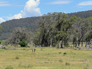
 Open country beyond the main gorge |
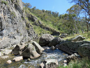
On reaching a small set of rapids, the gorge opened up and we wandered across a flatter area of snow gum woodland. Cave Creek was never far away though and two more crossings in succession brought us to another low limestone cliff. |
||
|
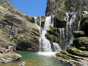
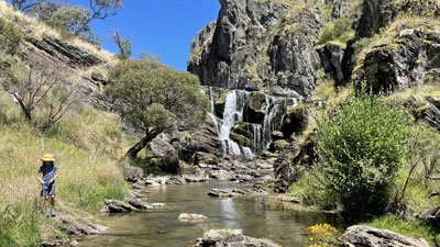
The sound of tumbling water told us that we had reached our destination, Cooleman Falls. Suddenly, the creek dropped over a sharp edge and beyond, a lower gorge wound its way down to the Goodradigbee River.
|
|

Although only a 15m drop, Cooleman Falls are one of the most aesthetically pleasing waterfalls that I have seen. We admired the multiple strands of the falls, sparkling in the sunshine as they tumbled down the uneven rockface and into a deep green plunge pool at the base. From the plunge pool, Cave Creek continued on, to cascade down its steep winding course into the wilderness country beyond. |
||
 The plunge pool at the base is a ...... |
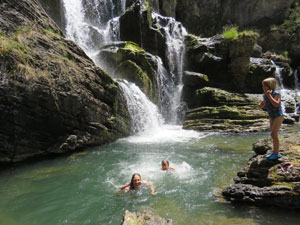
We picked our way carefully down the side of the falls to reach the plunge pool, a beautiful spot to stop and enjoy this wild landscape. The day was beginning to warm up and the grand-kids were keen on a swim - a jump from the large pool-side boulder, a splash, a squeal and a quick retreat. This water was icy! Icy water never stops children from having fun and soon they were jumping in and out with squeally delight. My daughter followed and, not wishing to be the wussy grandpa, so did I, for a very short but very refreshing dip. |
 .... great spot for an icy dip |
|
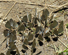
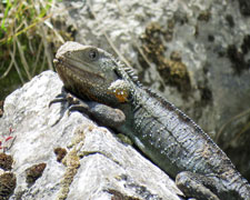
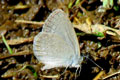
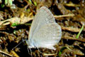
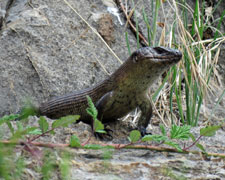
It was hard to turn back and retrace our steps, but the journey seemed very different as Clarke Gorge took on new aspects as we headed west through it. For a while the kids headed up stream on a longer creek wade, at one time under the watchful eye of a water dragon. Clouds of small butterflies sucking up the moisture from the muddy river's edge flitted about as we passed. For children, this place is full of adventure.
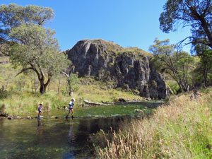
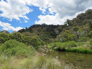
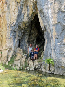
On reaching, the first (or on the return journey) last crossing, we followed the steam further westward, instead of climbing directly up to the cars - our destination The Blue Waterhole itself. A shallow, spring-fed pool, the clear water definitely has a bluish tinge, and backed by a limestone cliff and small cave to explore, lies in a lovely setting. With a healthy population of water weed, it was less inviting than the falls plunge pool and this time I didn't join the others for a swim. Sometimes its nicer to just watch others enjoying themselves. |
|


 Late afternoon light at Blue Waterholes |
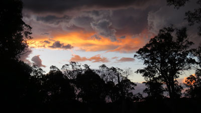 Cooleman Mountain sunset |
All too soon, it was time to head back up to the car and drive back to our campsite at Cooleman Mountain. This is a short walk, but packs more spectacular scenery into it than many longer walks that I have done. It is the perfect walk to share with young children and show them the wonders of our natural landscapes. |
|
|
Nichols Gorge Walk (7 km - 110m ascent - 110m descent) |
We made a short detour on the way down to Blue Waterholes for our second walk, to visit Coolamine Homestead. Set on the edge of a grassy plain, this property was owned by the Campbell family and used for summer grazing. It has been nicely restored and is well worth a visit to see how the original settlers lived. In fact, one of these was George Southwell, who lived here and managed Coolamine for the Campbells from 1892 to 1909, helping to build the main homestead in 1892. My three grand-children were quite chuffed to learn that this was in fact great-great-great-grand-uncle George. The fair Nello's family, the Browns, have lived in the Canberra region since 1835, and if you have been there that long, you invariably connect up to the Southwells, the largest of the early pioneering families in this area. It may be distant, but it was nice to have that family connection to Coolamine and the Blue Waterholes area. |
||
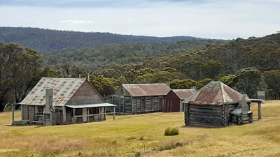 Coolamine Homestead |
 |
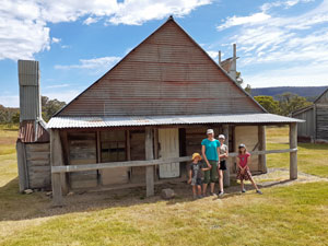 Family in front of the house that g-g-g-grand-uncle George built |
Then it was on to the Blue Waterholes carpark for our walk. Today we would be heading west, first following a 4WD service road down the hill to twice cross Cave Creek, as it wound its way across the snow grass flat a few hundred metres upstream from the Blue Waterhole. What a difference that short distance made, as here the stony bed of the creek was bone dry .... any water was flowing below the surface ready to bubble up into the spring-fed waterhole downstream. |
||
 Heading out across the snow grass plain |
 |
 Along the dry bed of Upper Cave Creek |
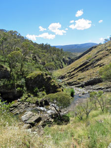
Just before a third crossing, we left the road to follow a well-formed and well-signed foot track along the thick grassy verge of the dry creek bed. Around us, the low winding cliffs that formed Nichols Gorge shaped the direction of the track. |
|
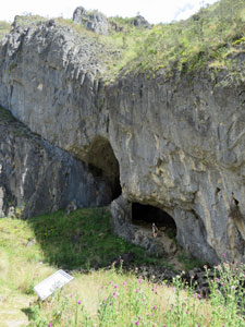
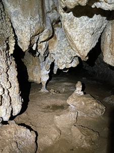
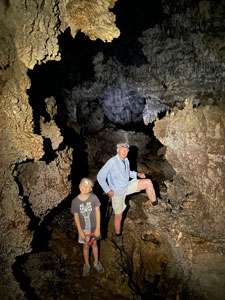
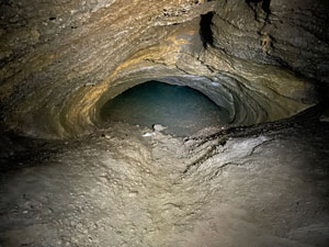
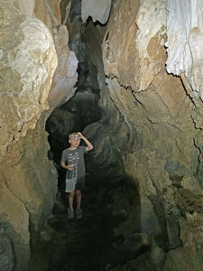
Soon, we arrived at the entrance to Coolamine Cave ..... a cavernous entry into the limestone rock wall on the north side of the creek. We crossed over and climbed into the cavern .... our first caving adventure was about to begin, so we reached in to our packs, took out our headlamps, ducked our heads and entered the low passage to our left.
|
|
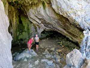

|
Not much further on, we emerged into a larger space, where we could stand up and admire the way water has created the curious rock shapes as it flowed through this erstwhile underground river course. The cave was also an active one, with the smooth calcite on the ceiling tipped with translucent droplets of water. A second low passageway led us deeper into the cave system to reach a smaller standing-up space. From this point, it became the realm of seriously-equipped cavers, so we returned to the opening cavern and, after a quick visit to the shorter right-hand passage, finished our caving. |
|
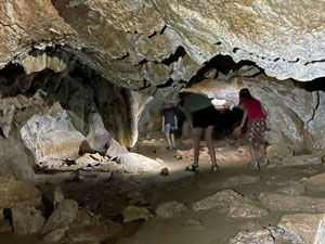
 |
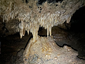
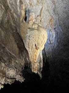
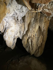 Formations in Cooleman Cave |
 (cave interior photos by Robyn Briese) |
 |
The day was heating up, even here, and the cavern entrance proved a pleasant place to stop for a snack in the shade, while cooled by a gentle breeze. From Coolamine Cave, we followed the river system, winding through the low-walled gorge, sometimes on the dry stony bed of the creek, sometimes through the dense mat of grass and herbs that lined it. The landscape here was very open, with no trees, so it was a bit of a relief to come across a small waterhole in the creekbed - an opportunity for the kids to have a wade in the cold water and spot the tadpoles that called it home. |
||
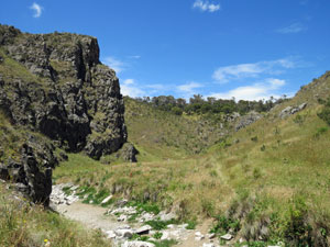 Cliffs and grassy slopes of Nichols Gorge |
 |
 An isolated water hole in the creek |
|
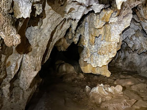
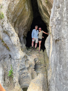
It wasn't far from the waterhole to the second cave. The entry to Murray Cave is a narrow vertical slot in the cliff-face, but behind it lies a large cavernous chamber and the air drafting out through this slot was deliciously cool.
To the left of the chamber, our headlamps showed up a narrow passage - narrow, but high, so no ducking or crawling required for almost all of our exploration. This passage wound its way some 200 m into the limestone rock to reach a siphon, where you could look down on to a small pond that blocked further exploration. This was the visible part of a vast underground water system.
|
|

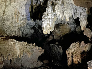
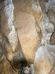
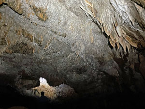 Looking at a ceiling of calcite tubes and shawls |
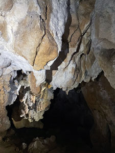
Along the way, we passed by some superb if fairly young formations - the ceiling and walls in sections covered with lots of tiny dripping calcite tubes, the occasional larger shawl and walls embedded with brachiopod and crinoid fossils. The photos here tell the story. Sadly, a lot of the more substantial features of this cave were pillaged in the 19th century by early visitors (I hope that it wasn't g-g-g-grand-uncle George). |
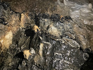 Fossils in the cave walls |
 |
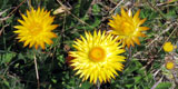
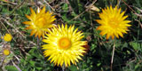
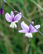
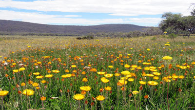
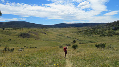
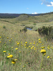
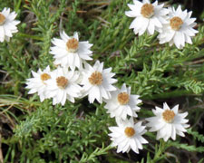
The cave was a good lunch spot, as afterwards we climbed up the steep slope beside the cliff onto the snow grass plateau above. Here the open vistas of the Cooleman Plains surrounded us, as we walked through patches of white and yellow paper paper daisies, skirted a couple of sink holes and passed copses of snow gums, all the time surrounded by the distant wooded slopes of the Gurrangorambla Range. This is brumby country and my grand-daughters had hoped to see some of these wild horses. Unfortunately, they had to be satisfied with the regular piles of horse buns, where brumby mobs had marked their territories. |
 |
 View from the plateau back to Cave Creek |
 A sinkhole next to a copse of snow gums |
 Crossing the snow grass plains |
|
|
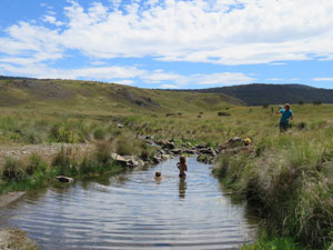
It was quite warm crossing the open snow grass, but, after dropping back down on to the creek system, we found a small (and warmer) waterhole where the kids could cool off. Energy levels recharged, we followed Cave Creek down to its junction with a smaller tributary. It was now time to head north across the undulating open grasslands to reach Magpie Flat Camping Area and the road, where a final short descent brought us back to Blue Waterholes and the car. |
|
||
 Time for a quick swim |
 |
 |
|
The last part of the walk had been quite hot and the idea of a swim in the lower section of Cave Creek began to take hold. The wide pool to the east of Blue Waterhole proved the ideal spot, despite its 14°C temperature. A quick dip here, beneath the limestone cliffs was a fitting end to an adventurous walk in this high country landscape. The chance to explore a couple of fascinating caves was a bonus. |
||
 Looking towards Clarke Gorge |
 |
 Swimming hole in Cave Creek |
|
And to complete the trip, as we drove back out the next day along the Long Plain, my grand-daughters got to see their brumbies, a group of three heading off up a side-valley, closely followed by a yearling .... cute, but sadly one more feral horse for the National Park. Thanks for sharing this trip, Robyn, Aisha, Lina and Leo. It was a great couple of days in a unique part of our high country. |
|
|