
| Nitmiluk Gorge - by foot and canoe |
Nitmiluk Southern Day-Walk (13.5 km - 310m ascent - 310m descent) |

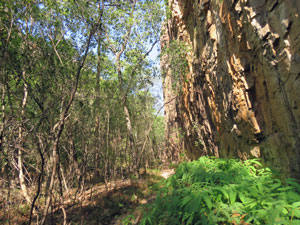
We last visited here in 1998, when it was better known as Katherine Gorge, rather than its Jawoyn name of Nitmiluk. Some changes are for the better and it was time to renew our acquaintance with this spectacular region. With the Northern Territory still under the influence of an extended heatwave, the forecast for our walk along the southern rim of Nitmiluk Gorge and its surrounding escarpment promised to be hot - 35°C in fact. An early start was called for and, after a 20-minute drive from our accommodation in Katherine to the National Park visitor centre at the gorge, we set out just after 8am. We headed quickly towards the Katherine River on a smooth asphalt track alongside a squabbling colony of thousands of fruit bats. To our right lay the edge of the escarpment and soon we were climbing up its side on a well-formed stepped path. A very new looking set of ladders brought us to another new steel lookout built out over the edge of the sandstone/conglomerate cliff. I'm sure this wasn't here when we visited some 25 years ago. |
|
|
 The escarpment wall rising above the plain |
 Climbing the escarpment |
 Freshie cruising in the Katherine River |

The lookout provide an outstanding panorama of the mouth of Nitmiluk Gorge, looking beyond the walls to the tree-lined Katherine River continuing on into the plain. It also looked eastward up into the first of eight gorges separated by rock barriers. Far below us, a freshwater crocodile swam slowly upstream as a tour boat cruised back down - such is the rhythm of life in Nitmiluk. |
|
 View westwards through the entry to Nitmiluk to the plains beyond |
 View eastwards up Nitmiluk Gorge |
We continued to climb steadily up a gravel track along the edge of the escarpment to reach some large water tanks and a water tap (kindly supplied by the National Park people and probably essential when temperatures regularly climb into the 30s). For the moment, a cooling waft of air accompanied us as we continued along on a 4WD track, following the Baruwei Loop, to its junction with the Yambi Track. |
||
|
|
|


Here we headed down to the Southern Walks Trailhead, and its water tank, before heading off back towards the gorge via the Windolf Track. The escarpment here comprises a series of rocky outcrops separated by richly vegetated gullies - palms, eucalyptus and bright green understorey shrubs - and the track meandered its way around these outcrops to eventually head down a gully to the gorge wall. |
||
 Meandering through the gullies |
 Rock outcrops on the escarpment |
 Wall of the Southern Rockhole side gorge |
To our left a track descended to Southern Rockhole, which has a spectacular waterfall in the wet season, but is dry now. We had a look into the side-gorge, but decided not to make the detour. Instead, we headed out to Pat's Lookout, with its spectacular vistas up and down the First Gorge. The slight air movement was still cool, even though the day was heating up.
|

The track (now the Waleka Walk) followed the cliff line, wending in and out, to reach our next viewpoint, Jedda's Rock, named for a scene from an iconic Australian outback movie. The views of the Second Gorge were nice, but Pat's Lookout was a clear winner. Still, we did see where our canoeing trip tomorrow would start from. |
|
 The start of the Second Gorge |
 Second Gorge zig-zag from Jedda's Lookout |
Completing a small circuit, we returned to Waleka Track to climb steadily up the rocky tops of the escarpment. To our left lay the deep cleft of Butterfly Gorge, one of the bigger side-gorges. The vegetation here was more open with lots of exposed rock to reflect the heat and we were definitely working up a sweat now. |
|
 Walls of Butterfly Gorge cutting into the escarpment |
 View over the escarpment plateau to the ranges beyond |
Finally, reaching the high point, we dropped quickly to rejoin the Yambi Track at a nicely located water tank. It was a good place for an early lunch in the shade. The temperature was well into the 30s now, but from here we followed a gravel 4WD track on a gentle climb up a creek system - with lots of shady trees - as it wound its way through the sandstone outcrops.
At the end of the creek, the track climbed over a longer rocky ridge to rejoin the Southern Tracks Trailhead. To complete the bottom of our figure-8 circuit, we diverted from our outward route on a gravel road that led us down through a narrow gap in the escarpment wall to reach the flats below. |
||
 Descending the exit gap from the escarpment plateau |
 Dry plains vegetation below the escarpment wall |
 A hot route home |

All that was left was a tiring walk through the open dry scrubland of the plain - the air was still and the sun beat down ferociously as it reached the expected 35°C - all of which made the bottle of icy cold chocolate milk back at the Visitor Centre taste that little bit better at the end of walk. Despite the heat, the route that we took was a really nice one combining great views into Nitmiluk Gorge with the tree-lined watercourses and bare rocky outcrops of the escarpment. It whet our appetites for a closer exploration of the gorge by canoe tomorrow - unfortunately the forecast is for 35°C again. |
|


Canoeing Nitmiluk Gorge - day 1 (5 km) |
We had booked the Barrak Barrak Tour, an overnight canoeing trip into the heart of Nitmiluk Gorge. For that, we needed to be up early to get to the Katherine River boat landing at the gorge entry for an 8am start. It was a typical pleasantly cool start to what would be a very hot 35°C day. The boat, filled with 40 plus canoeists, pulled out into the middle of the river, rounded a yawning freshwater crocodile and headed up into the First Gorge. Canoeing (or swimming for that matter) is not permitted in the First Gorge due to the possible presence of a rogue saltwater crocodile. Not only do salties eat freshies, but they wouldn't turn their back on a juicy human. This is not natural saltie habitat, but the young males roam up here in the wet season. At the beginning of the dry they are trapped and removed, safe enough in the Second and higher gorges behind their large rocky barriers, but still a small risk in the open First Gorge. |
 Reflections in Nitmiluk Gorge |
 Still morning light at Nitmiluk |
 Nice smile from a freshie |
 Walls of the First Gorge |
Canoeing therefore begins in the Second Gorge and, after a pleasant trip up, admiring the high sandstone walls of the First Gorge in the clear morning light, we disembarked, crossed the barrier and collected our canoes and gear at the canoe base. Fortunately, most of the canoeists were half-day or day-trippers - they headed off quickly, leaving us few remaining overnighters to load our tents, food etc and paddle off more sedately. |
||
 Setting out on the Nitmiluk canoe trip |
 The cliffs of Jedda's Rock tower above the river |
 The beauty of the Second Gorge |
|
Soon we were paddling smoothly up the Second Gorge, with its magnificent undercut cliffs. A cooling breeze flowed down between the sheer orange and black sandstone walls and ruffled the water of the Katherine River - superb. |
|
|
 Heading up the shady gorge floor |
|


A sharp right-hand bend and short reach brought to the mouth of a long tree-filled side-gorge. We had reached Butterfly Gorge and pulled in to tie up on a water's edge tree. Here, we disembarked for a short walk up this deep and narrow gorge, with its microclimate supporting a shady canopy of remnant rainforest trees and small creek with several clear shallow pools ...... and, yes, there were butterflies, flitting between shrubs or spreading their wings on the cool rock walls of the gorge. |
||
|
 Deep in Butterfly Gorge |
|


|
It was only a short diversion, and soon we were back on the river paddling steadily up a long reach between tall cliffs. This brought us to the end of the Second Gorge, where a narrow rocky bar blocked the river. The way through was to haul the canoe up a small set of rapids and into the Third Gorge - it was our first portage. The Third Gorge continued the amazing rolling panorama of red sandstone cliffs. It is a shorter gorge, however, and soon after passing the entry to Golden Gorge, another side-gorge, we reached its upper barrier, The Vortex Holes, and the start of a long and arduous portage. |
|


The Vortex Holes consisted of a jumble of big boulders, which had been shaped and smoothly hollowed by swirling wet season floods. They largely blocked the river and we had to haul our canoe up a narrow and slippery rapid. However, as they say on that TV sales show "and that's not all". Ahead lay the Dry Rapids - not dry at all, three broad jumbles of smaller boulders blocked our path, with a braided set of shallow streamlets cascading down between. Again, we had to haul our canoes up through this maze, manouevring around or over protruding rocks and trying to pick the best flows to follow up. It was a long, hot and hard slog, with many a slip and splash on the slimy rocks. By the time we reached the Fourth Gorge, my hands were cramping. |
||
 Arriving at The Vortex Holes |
 Barrier between the Third and Fourth Gorges |
 View into the Fourth Gorge from the Dry Rapids |
We paddled on, a bit more slowly now from the exertion and the increasingly hot day, to reach a sandy pull out where we stopped for lunch and energy recovery time. Not all sandy beaches are accessible in Nitmiluk, as its is now freshwater crocodile breeding time and they lay their eggs in the sand - NP rangers had put up "no landing" signage to protect these nestsites. |
|
 Heading towards Smitts Rock in the Fourth Gorge |
 Pulled over for lunch on a sandy beach |
Lunch over, we climbed back in to paddle on through a narrow section of the gorge beneath Smitts Rock, an enormous sandstone mesa that formed a semi-island in the gorge, one side being the river course and the other a dry channel that no doubt flowed in the wet season. |
 Rest stop at a sandy dune east of Smitts Rock |
At the far end of Smitts Rock, we reached a broader area of the river, passing by a shallow sandy section of river bed with sand banks on either side. Although not indicated, this was obviously Smitts campsite, our destination for a night beneath the stars. Not stopping just yet, we paddled up a few hundred metres further to reach the big blocky boulder bar that marked the end of the Fourth Gorge and climbed up to look down the length of the Fifth Gorge (as expected a long reach with sheer sandstone walls not to be outdone by the earlier gorges). |
 The sheer walls of the Fifth Gorge |
We returned to the sandy beaches to set up camp, choosing the southern side of the river, where we could pitch our tent on the flat of a dune in the deep shade of Smitts Rock's impressive wall. With the temperature now at 36°C, this was a major factor in choosing a spot to while away the afternoon. |
||
 Smitts Rock campsite |
 A swim in the sandy channel of Fourth Gorge |
 Contemplating the evening stillness |
It was a lovely spot and we were soon down on the sandy beach, soaking away the sweat and hard work in the cool refreshing waters of the Katherine River. It was the perfect place to spend a night and, even better, no-one else had set up camp here. We had the Fourth Gorge to ourselves .... along with the frogs, birds, micro-bats and crickets ... and the stars were simply magnificent. |
|


Canoeing Nitmiluk Gorge - day 2 (5 km) |
|
It had been a very tranquil, if warm, night under the stars in the Fourth Gorge, shared with the crickets, frogs and insectivorous bats - starry at least until the moon rose and bathed the night sky and surrounding landscape in a pale light. The sun rose at 7am, a glowing ball in the gap between the walls of the Fifth Gorge to our east - spectacular. We broke camp quickly, having decided to head back in time for the midday ferry down the First Gorge, rather than the 5pm one - an afternoon cooking in the hot sun didn't appeal and temperatures were forecast to again reach 36°C. |
|


By 8am, we were back on the waters of the Katherine River heading west down the Fourth Gorge - the bow wave of the canoe setting up a gentle ripple in the still water. All around the tall orange sandstone cliffs and riverside vegetation offered beautiful early morning reflections. It was a great time to be on the water. |
|
 Early morning reflections ...... |
 ... on the glassy waters of Nitmiluk |
Our reveries were spoiled, however, by our arrival at the top of the Dry Rapids portage, with its jumble of boulders and multiple channels. It was slightly easier work to descend than to come up, as this time the current worked in our favour when we manouevred the canoe around and over rocks and through the narrow gaps. Still, a lot of slipping on slimy boulders, twisting and heaving, and the odd 4-letter words of encouragement to the canoe took place before we finally exited the bottom of The Vortex and the end of the portage. |
||
|
|
|
The slow paddling descent down Third Gorge was a relief. With time up our sleeve, we took the opportunity to moor at the entry to a small side-gorge and follow a track up and in to have a look at The Lily Pond - a large and deep waterhole at the base of a sheer black and orange sandstone cirque - a lovely spot. |
||
 The Lily Pond side gorge |
 Deep waterhole at Lily Pond |
 The orange-walled cirque backing Lily Pond |


Then it was back into the canoe to complete the descent of Third Gorge and make the final short and easy portage back into the Second Gorge. We were well ahead of time now, so could afford to paddle slowly and occasionally drift down the long straight of this gorge and appreciate more closely the beauty of its sheer rock wall. |
||
 Entry to Golden Gorge |
 Descent from Third into Second Gorge |
 Orange walls of the Second Gorge |
A last zig and zag as the gorge made right angled changes in direction, plus one last cooling swim in the shade of a sheer rock face, brought us back to the canoe base to return our faithful craft, with only a few more scratches than before from the rough rock portages. |
||
 Final paddle back to the canoe base |
 |
 Can you spot the swimmer? Hint - it's me |
The midday ferry arrived and we joined some of the half-day canoeists to head back down First Gorge to Nitmiluk Centre - a couple of freshwater crocodiles watched from the bank as we passed, while the trees at the boat dock seemed to tremble as the thousands of fruit bats quivered their wings to cool down in the hot afternoon sun. Our Nitmiluk canoe adventure was over - it had been a lot harder work than we anticipated, but for the beauty of the gorges and their surrounds and the tranquility of a night to ourselves in the heart of this landscape, every little ache and pain was worth it. |
|
